Bikepacking in the Northern San Francisco Bay Area
Work brought me to San Francisco recently and I used the opportunity to have a bikepacking trip again. Over the last few months, I have been exposed to many new ideas, career options, and changes in my personal life. A one-week solo trip seemed perfect for me to mentally sort things out and let things settle. In the past, bikepacking always put me into a sustained state of flow, and I approached this trip like I would a meditation retreat - time I am explicitly giving myself to not think, but experience.
The Route
Before setting out, a few locals reached out to me and gave me recommendations, many of which I integrated into my (very loose) route planning. I love how helpful the international cycling and bikepacking community is, and how forthcoming everyone who heard about my plans was with tips. I’d love to pay it forward, feel free to reach out if you are planning a trip in the area!
I decided to head north from San Francisco, across the Golden Gate bridge and then up into the Marin Headlands. I chose to head north mainly due to the fact that the Marin Headlands, Mount Tamalpais and the general area is the spiritual birthplace of mountain biking, and I wanted to experience the trails firsthand. That being said, I also strongly considered a trip south toward Big Sur, and ultimately a few personal recommendations in favor of Marin and Point Reyes in particular made the difference.
Unlike with previous trips, I didn’t plan the full route in advance, and just set out with the rough idea of meandering north, taking a trip to Muir Woods, spending at least one day on Point Reyes, and making my way back along the Russian River, via Santa Rosa, Petaluma and San Rafael. I figured that the distances were small enough (San Francisco to the Russian River is only 50km as the crow flies) that I could always make it back to the city in one day if needed, and would never be too far from civilization. This is in stark contrast to my touring around Iceland, which required careful planning to make sure I could actually cover the ~1200km in 2 weeks. Planning less in advance served me well for this trip, but I generally recommend booking campsites ~a month in advance when bikepacking through National and State Parks, as capacities are very limited and they are often fully booked, particularly on weekends. I was lucky that I was traveling in the off-season and managed to get the last available spot at Wildcat campground just one day in advance.
Bike & Equipment
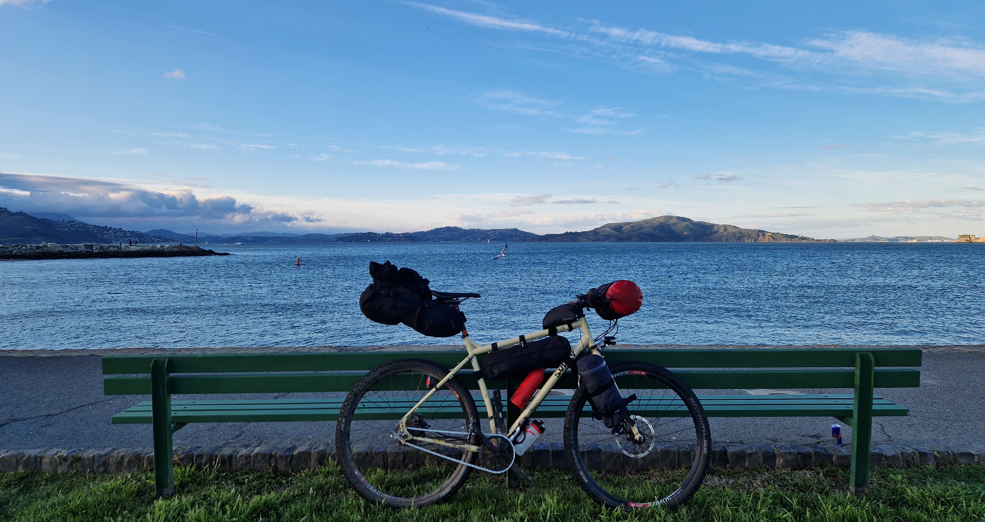
I rode my Surly ECR with an ultralight bikepacking setup: Rohloff Speedhub internal gearbox, flat bars, Schwalbe Smart Sam tires, and a mixture of bought and self-made bikepacking bags. I used two Salsa Anything cages on the front fork to hold my tent and sleeping pad, respectively. My clothing went in a Zefal front roll on my handlebars; raingear in a Topeak frame bag, and everything else in a Topeak saddle bag. For roadside repairs, I took my Gerber Suspension NXT multitool (big recommendation, mainly for the pliers and knife), a Crankbrothers wrench set & chain repair kit, a minimal first aid kit, tire valve adapter, 2 tire levers, a tire patch kit, a chain quick link, and a spare inner tube. Aside from the chain repair kit and valve adapter, I ended up using all of these on this trip.
Setting Out: Marin Headlands
I started on a Saturday afternoon in central San Francisco, rode across the Golden Gate bridge and on the Bridgeway along the Bay through Sausalitos, staying in a hotel just outside of Mill Valley. I had intended to camp out, but all campgrounds in the Marin Headlands within range before nightfall were either fully booked or closed for the season. As a precaution, I booked the Wildcat and Sky campgrounds for the following two days. The ride out of San Francisco is great as both bike infrastructure and driver awareness in the Bay Area is fantastic. Crossing the Golden Gate bridge makes for great views, but the noise and pollution of heavy car traffic on the bridge makes for a mixed experience.
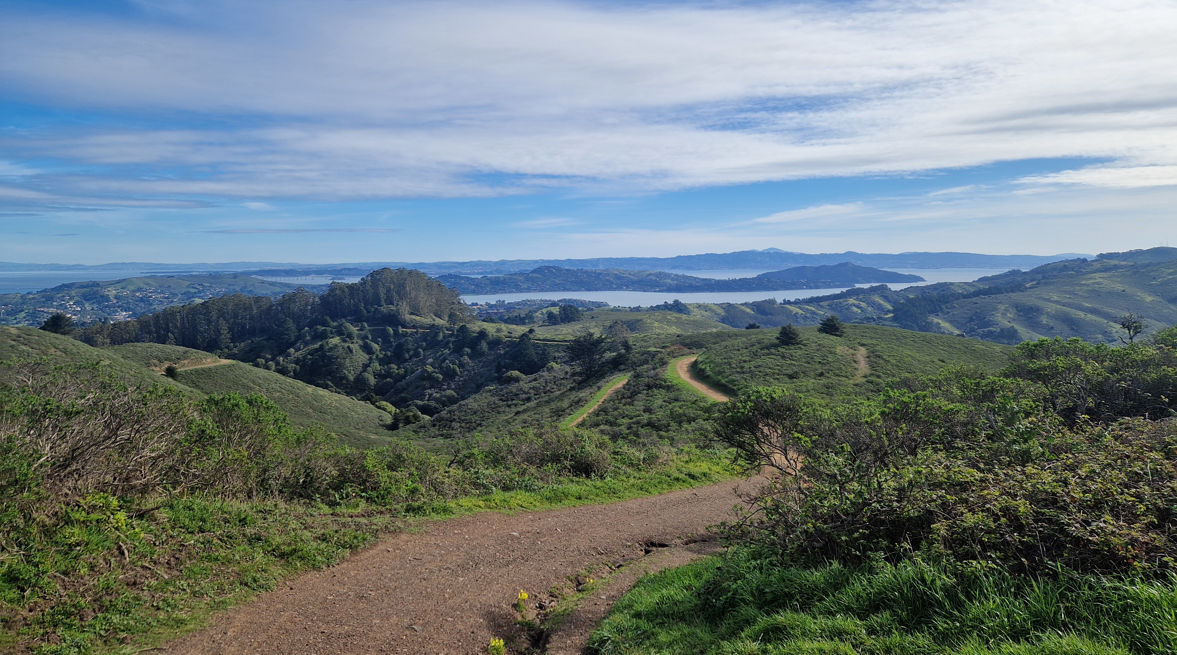
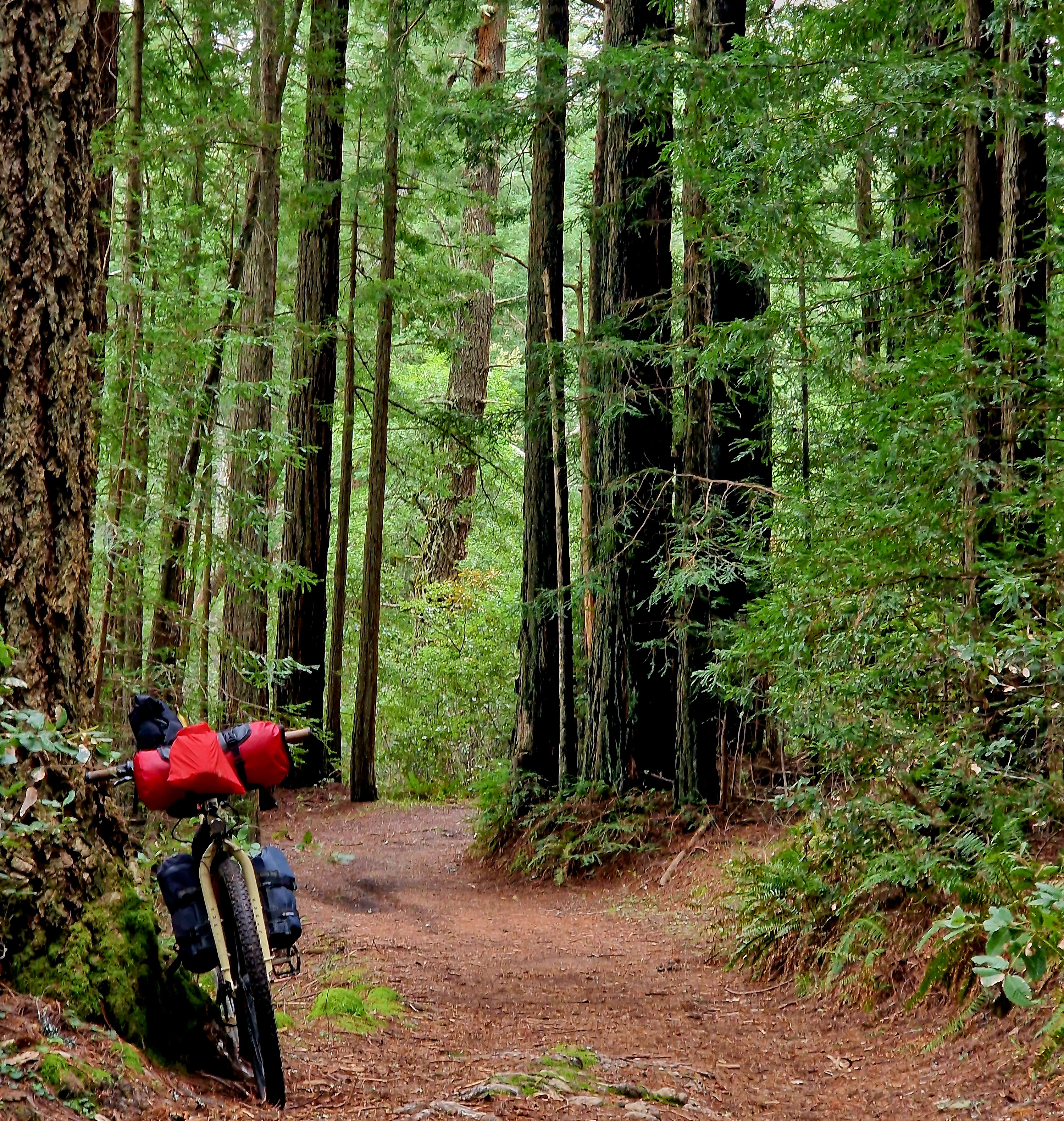
On Day 2, I set out on a meandering route through the Marin Headlands. I started up Tennessee Valley Road and braved a brutal ascent up Coyote Ridge Trail, which made me wish for bigger tires and less weight on my loaded bike. The views out onto the Pacific coastline, Muir Beach and the rolling hills of the Headlands made the climb well worth it. I continued on through Frank Valley to the Muir Woods National Monument, a large grove of old-growth redwoods set in the valley of Redwood Creek. As cycling is not allowed in the park, I left my bike at the entrance and went for a hike. The hiking in Muir Woods is gorgeous, and I imagine it would be even better on a weekday morning when there are fewer visitors, though the park did not feel crowded by any means. Hiking Muir Woods takes anywhere between one and three hours, depending on the chosen trails.
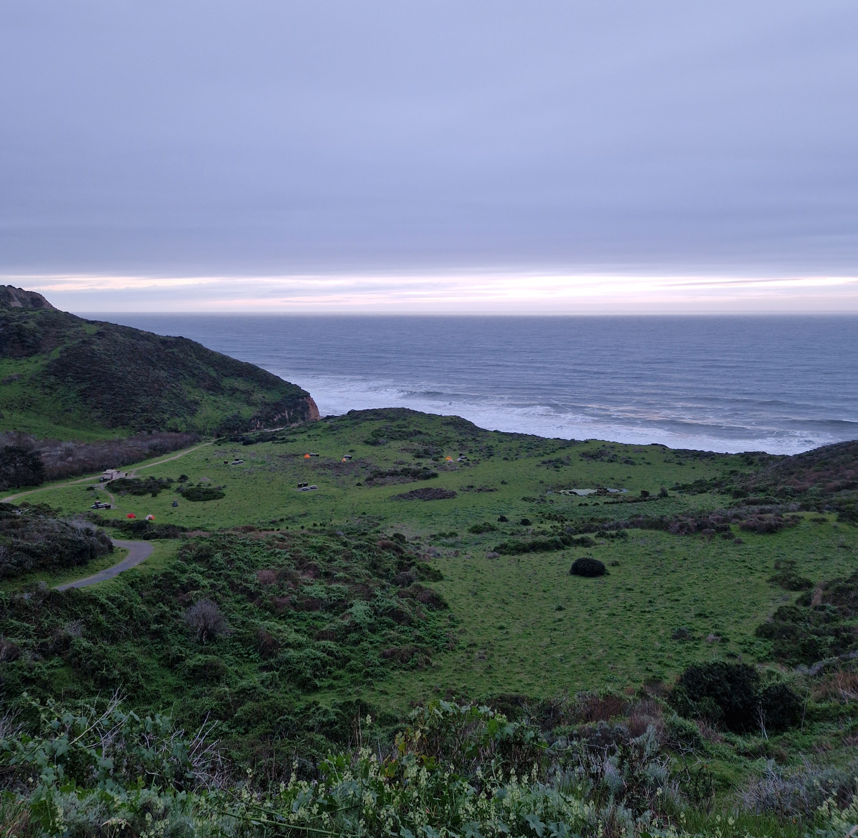
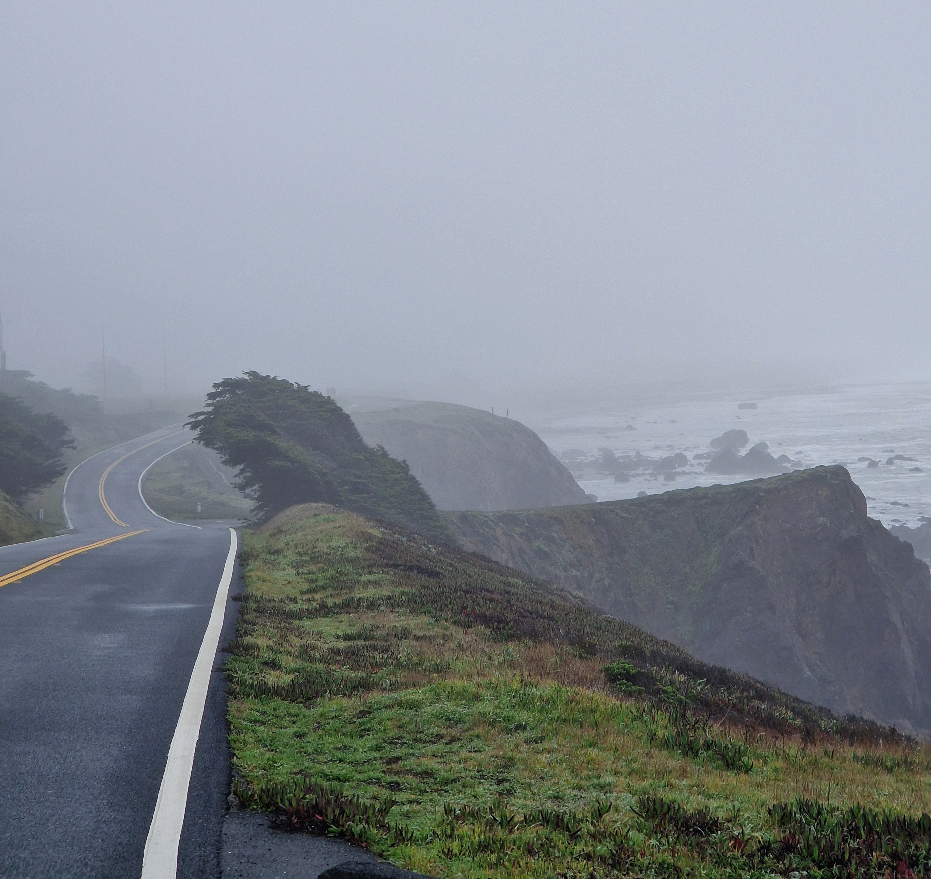
I left Muir Woods after lunch, climbed up Cardiac Hill on the Deer Park Fire Road, and had an absolute blast following the Bolinas Ridge Trail, which was just the right kind of solid gravel and gentle grades for my setup. The Wildcat campground is set spectacularly on a cliffside overlooking the Pacific Ocean. To get there, I had to descend from the Bolinas Ridge and cross another mountain range along the Stewart trail. Despite the trail being a smooth fire road, this last climb pushed me to my limits and I reached camp barely before nightfall, greeted by the white-tailed deer that roam freely on the campground. I was rewarded by the dramatic view of the stormy Pacific crashing into the cliffs of Point Reyes in the twilight, and fell asleep to the sound of the waves.
Steep Climbs and Dramatic Cliffs: Point Reyes
For Day 3, I had planned a lower-mileage, “easy” day with much less overall elevation. As the Stewart Trail is the only bikeable trail to and from the Wildcat camp, I had to make the climb again, but this time with rested legs. On the other side, I decided to stay on the Shoreline Highway and head to Point Reyes Station, and then via Sir Francis Drake Boulevard to Inverness for breakfast. Inverness, aptly named, lies on the long, straight and Loch-like Tomales Bay, which was teeming with bird life and featured a small shipwreck as its sole non-natural attraction. I felt good and the weather was great, so I decided to push on and turn back up into the interior of Point Reyes, climbing up Mount Vision and Point Reyes Hill, which gave gorgeous views over the slopes of Point Reyes down to the Pacific. If I hadn’t intended to treat this as a quasi-rest day, I would have fully crossed the mountains for the Coast Trail along the Pacific shore, but I felt like I wanted to keep my commitment of not overexerting myself. I arrived in the late afternoon at Sky Camp on Mount Wittenberg, another National Park Service campground in a dramatic setting, overlooking slopes that must have recently been burned in a wildfire. A rainstorm made for a restless night, but the pines protected me from most of the wind and rain.
The Troubles: Bodega Bay and the Russian River
In clammy, foggy weather, I made my way down the mountain, had breakfast at the Bovine Bakery in Point Reyes Station (delicious pastries) and followed Highway 1 along Tomales Bay and, with minor deviations, on to Bodega Bay. This section of Highway 1 is easily bikeable and didn’t have much car traffic, though the landscape becomes dramatically more interesting as the road bends inland and the hills, heightened by the persistent fog and strong winds, take on a distinctly Highland-like appearance. That part of the coast was vividly green, even in February, and dotted with small dairy farms, pastures, and large, rounded rock formations. Ominously, vultures were circling in the sky. I rolled into Bodega Bay, a small oyster-fishing and resort town, with most of the bay obscured in dense fog. The campground I had chosen was on the beach, and I had been looking forward to camping in the dunes, a warm shower and scouring up whatever vegan food I could find in a fishing town. The fog was deadening all sounds but the repeating sound of a fog horn on the edge of the bay, presumably warning ships. That fog horn sounds every 15 seconds 24/7, according to a local resident, regardless of the weather. As I was putting up my tent, it began to rain, and that rain would turn into a severe rainstorm that would last all night. Bodega Bay was where much of Hitchcock’s Birds were filmed, and I had dinner at the Birds Café. During the storm the night before, my bike had sat out in the rain, and my lights had stopped working. I anxiously biked back to camp in the dark and rain, to find that water had begun to leak into my tent from the bottom. As I bent my air mattress back to check the floor under it, it popped and quickly began leaking air. I booked a hotel for the night and enjoyed the unexpected luxury of another hot shower and a warm, dry bed.
Due to the loss of my sleeping pad, I slept in hotels for the rest of the trip. Suddenly, the approach of not booking campgrounds until the night before ended up paying off, but I would generally not recommend it in National Parks and the high season. To the sound of the fog horn, I set off that morning warm and dry on Highway 1, along the coast blanketed in fog. The coastline north of Bodega Bay is dramatic, with waves crashing into large, black rocks protruding from the sea, and steep cliffs forming small bays with picturesque beaches. I met a man who told me of his mountain biking exploits back in the 80s, and cycle tours through Germany with his buddies. He recommended I take a dirt road inland, but I wanted to follow the coastline for a while longer. About 10km north of Bodega Bay, I had a flat tire and quickly swapped in the spare inner tube. I turned out to have brought a road bike inner tube by mistake, which I had to overinflate to fit my mountain bike tires. A wobbly 5km later, I hit the Russian River and turned inland, staying on paved roads and hoping my cobbled-together setup would hold out until the next bike shop. The inner tube blew up 100 m away from a gas station, where I found the puncture in the original inner tube by submerging it in a puddle and patched it with my patch kit. At that point, I was ready to call it the end of the trip, jump on a bus to Santa Rosa and rent a car to get back to San Francisco, but challenged myself to fix the tire before the next bus arrived. During that repair, I had a few wonderful interactions with people passing by, who offered help, moral support and use of a full-size bike pump, which made the inflation experience much smoother than my small portable pump would have done. The patch held for the remainder of the trip.
I made my way along the Russian River (I recommend fire roads over the paved road here, as there is a lot of car traffic), picked up a new backup inner tube (mountain bike size, this time) and rolled into a motel in Santa Rosa before nightfall. My main technical takeaway from the day was that carrying a pump, tire levers, a spare inner tube and a patch kit as a backup can save your trip, as do basic bike repair skills. While my next ultralight tent will be double-walled and probably a bit more spacious, that sub-300€ single-walled tent had performed well for 5 multi-week bicycle trips. My sleeping pad had been Therm-A-Rest’s flagship model, so I am unsure what to replace it with. My main takeaway from the day, however, was not technical as much as mental: I felt resilient and confident in my ability to overcome not just mechanical challenges, but also the frustration of finding myself temporarily unsheltered in the rain. Had my sleeping pad broken in one of the more remote campgrounds, this trip could have ended with a multi-hour hike-out, and I am grateful it did not.
Santa Rosa to Fairfax and Mount Tamalpais
Santa Rosa itself is a tough town for bikepackers, as it is a city built for cars with most of its cycling infrastructure confined to bike lanes on the sides of very busy highways. I was glad to get out of town and into the gently rolling hills of wine country. From Penngrove, I followed a bike trail along the train tracks to Petaluma, where I had fantastic coffee at Avid. I wanted to cover more serious distance that day and slowly climbed up the mountains on paved roads toward Nicasio Reservoir in gorgeous sunshine and abundant beautiful views. From there, I followed the Lucas Valley Road through redwood groves and wooded mountain slopes to the outskirts of San Rafael and cut a snaky path to Fairfax. Fairfax, along with Mill Valley and the other communities around Mount Tamalpais, is known as the birthplace of modern mountain biking. I made a beeline for the Fairfax Bike Museum, which has a very large collection of often historically relevant, sometimes fascinating and beautiful bikes from the 1900s to the present. I ended up spending over two hours there and spontaneously ran into Jacquie Phelan, former mountain bike champion and inventor of gravel biking, who, like everyone I met on this trip, was just heartwarmingly nice and recommended me a route up Mount Tamalpais (“Mount Tam”) for the next day. Museum staff recommended I check out Gestalt Haus, a watering hole for the local cycling crowd, and it is one of these places where it is impossible not to meet fascinating people and talk shop about bikes.
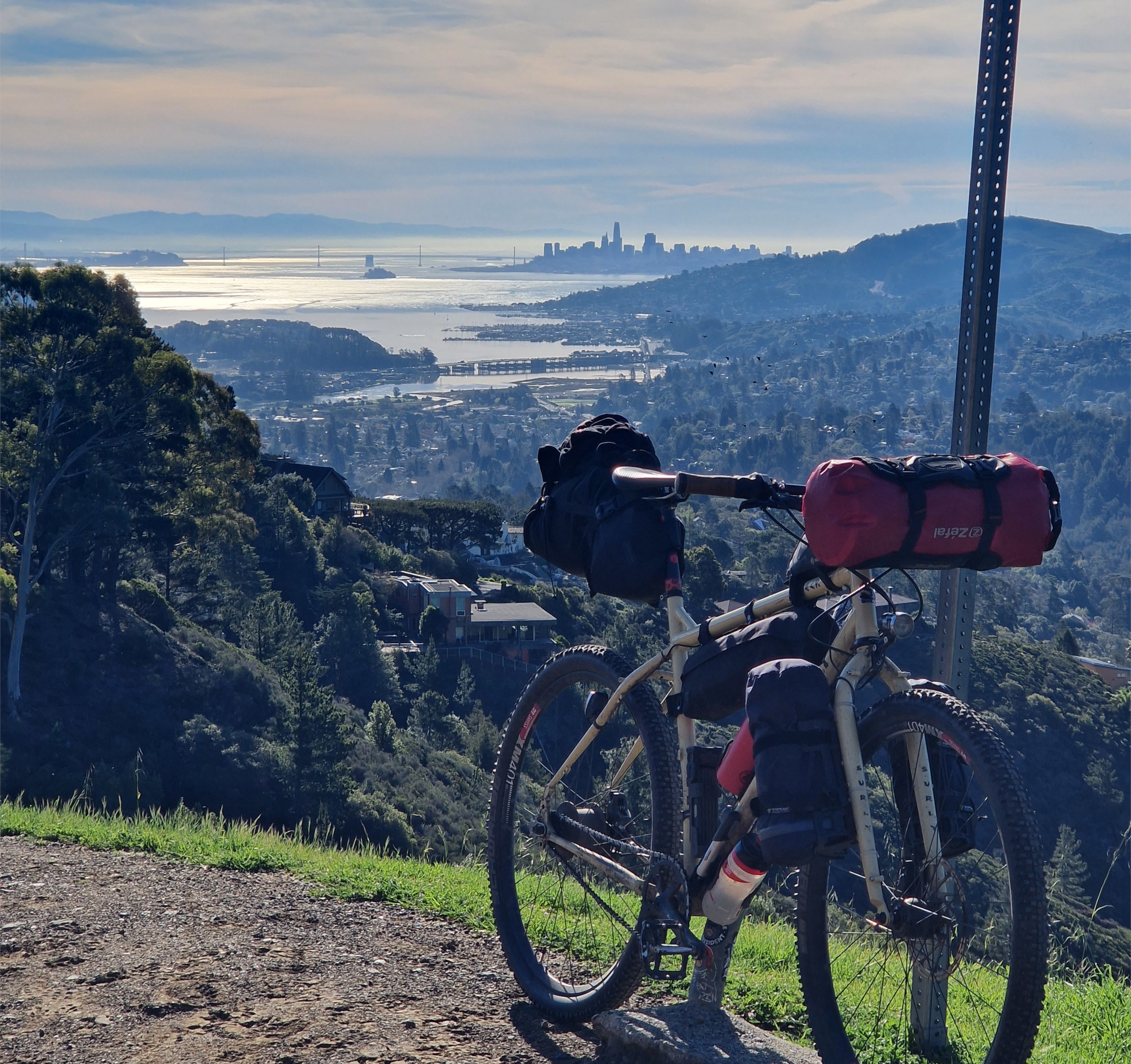
The next day, I set out from Mill Valley on a curving path through neighborhoods of beautiful houses up Mount Tam, which rises over the Bay and the Marin Headlands. The houses ended with the tree line, and the pines and redwoods yielded to shrubs, I had phenomenal views over the entire San Francisco Bay. As per Jacquie’s recommendation, I took Old Railroad Grade, a fire road that snakes its way up the southeastern side of the mountain at a near-constant incline and rode along the crest of the mountain toward its west peak, from which one has unobstructed views over the Marin Headlands toward the Pacific. I had a great descent down Pantoll Road back toward Mill Valley. I had great coffee (and more shop talk about bikes) at Equator Coffees in Sausalito and made my way back to San Francisco across the Golden Gate bridge.
Takeaways
For me, the loop Marin - Point Reyes - Russian River - Santa Rosa - San Rafael was perfect for the week-long, reflective, unhurried trip I had had in mind. It combined physical challenge (many short-ish climbs) with gorgeous camping and beautiful views, particularly on the shore of Point Reyes and from Mount Tamalpais. The route strings together several national and state parks, that can feel remote, particularly at the State Park campgrounds, while never being so far away from civilization that I could not hike to shelter within a few hours. This gave me the security to approach this trip without much prior planning, and allowed me to spontaneously change my plans when I wanted an easier day, got local route recommendations or had to react to equipment failure. As usual with bikepacking trips, I often found a flow state that I rarely achieve for such long sustained periods, and could, at times, fully disengage from mental chatter and just be.
I take away a renewed appreciation for good rain gear (rain pants!), drybags, and basic tire repair and bike maintenance supplies. Beside the tire changes, I had to re-tension the chain and adjust the rear brake alignment to avoid brake rub (I had just installed new brake pads before the trip), making good use of my tools. A powerbank is an absolute must when camping out at remote campgrounds. I am still in search of a good inflatable sleeping pad that does not leak or break. And I finally want to go give my Rohloff drive train the belt drive treatment it deserves.
Enjoy Reading This Article?
Here are some more articles you might like to read next: